Two systems for short-range limited area numerical weather prediction (NWP) are currently in use at the Hydrometcentre of Russia:
- System on the basis of ICON model (primary system since Autumn 2025);
- System on the basis of COSMO model (previous system).
Description of System on the basis of ICON model
1. System
- System name: ICON-Ru13/6N29
- Date of implementation: 01.12.2024
2. Configuration
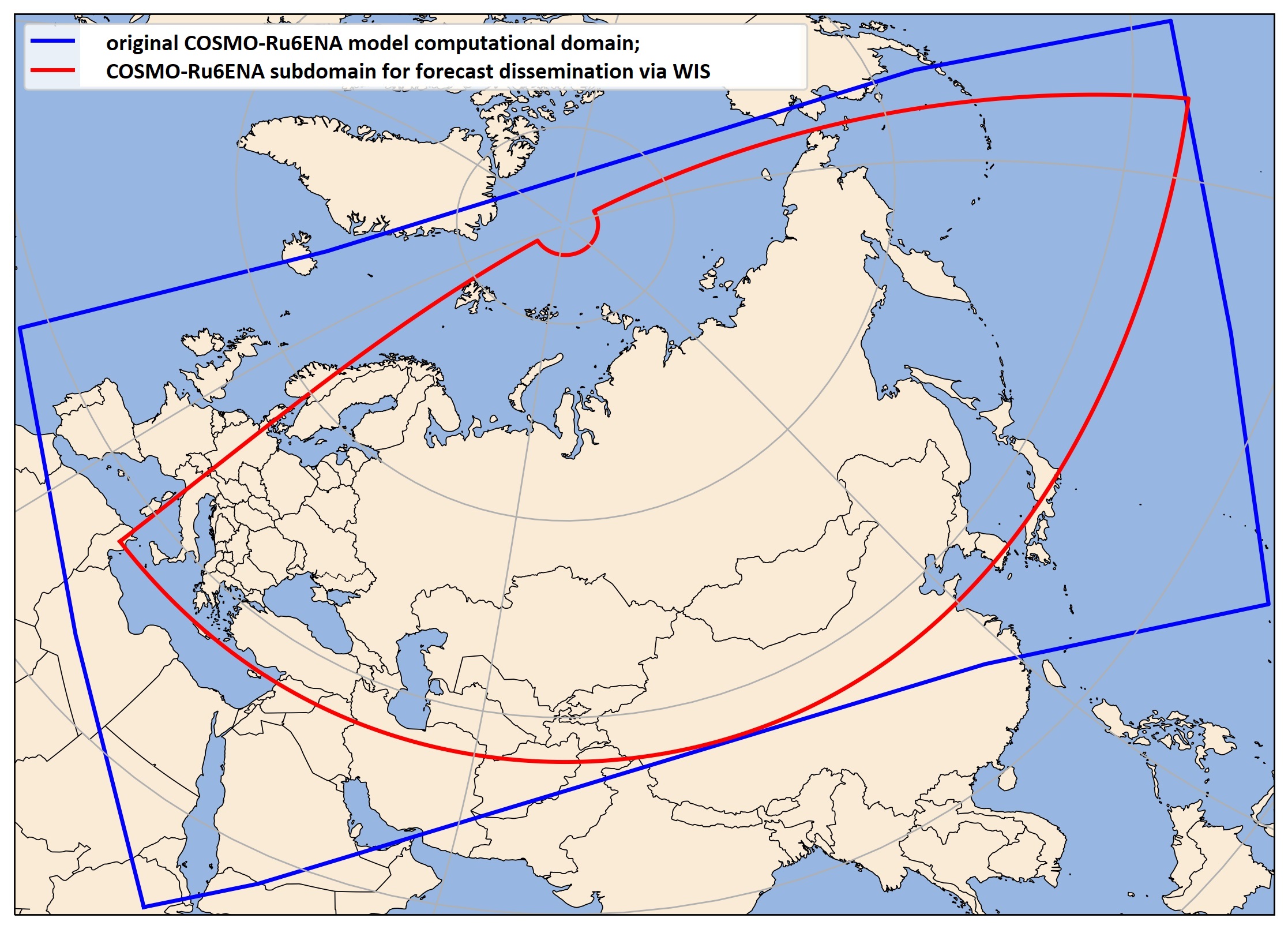
- Domain: Computational domain 29.5⁰-90⁰N, 180⁰W-180⁰E with grid spacing 6.5 km is nested into global domain with grid step 13km. Domain for forecast dissemination via WMO Information System 2.0 - to be identical to the COSMO-Ru6ENA subdomain (Fig.2, red contour)
- Horizontal resolution of the model, with indication of grid spacing in km: 6.5 km
- Number of model levels: 74
- Top of model: 23 km
- Forecast length and forecast step interval: 120 hr, 1 hr before 72 hr, 3 hr after 72 hr
- Runs per day: 4 (00, 06, 12, 18 UTC)
- Is model coupled to ocean, wave, sea-ice models? No
– Integration time step: 60 s
– Additional comments: nested to the global configuration (ICON-Ru13)
Fig.1. Subdomain of ICON-Ru13/6N29 system for forecast dissemination via WIS 2.0.
3. Initial conditions:
– Data assimilation method: None yet
– Additional comments: DWD (ICON) open data for the globe
4. Surface boundary conditions
– Sea-surface temperature? If yes, briefly describe method(s):
– Land-surface analysis? If yes, briefly describe method(s):
– Additional comments:
5. Lateral boundary conditions
– Model providing lateral boundary conditions: global configuration ICON-Ru13 (grid step of about 13 km)
– Lateral boundary conditions update frequency: two-way nesting, coupling with nested domain each 120 s
6. Other details of model
– What kind of soil scheme is in use? TERRA (with tile approach) (Heise, Schrodin, Shults)
– How are radiations parameterized? ecRad scheme, Aerosol climatology - CAMS climatology (Poliukhov A.A., Gvozdeva A.V., Piskunova D.A. - Effects of the Vertical Aerosol Structure on Short-range Air Temperature Forecasting and Clear-sky Shortwave Radiation Calculations in the ICON Model - Russian Meteorology and Hydrology, Allerton Press Inc. , Vol 49, № 8, pp. 711-721 DOI, Effects of aerosol climatologies on weather forecast in NWP models / A.A. Poliukhov, D. V. Blinov, N. Y. Chubarova et al. // AIP Conference Proceedings. — 2024, Vol. 2988, P. 080008. DOI: 10.1063/5.0182768)
– What kind of large-scale dynamics is in use (for example, grid-point semi-Lagrangian)? Grid-point Eulerian, triangular grid, Finite-volume method
- Hydrostatic or non-hydrostatic? Non-hydrostatic
– What kind of boundary layer parameterization is in use? Prognostic TKE
– What kind of convection parameterization is in use? Mass-flux shallow and deep convection
– What cloud/microphysics scheme is in use? Single-moment scheme, cloud diagnostic scheme by Koehler
– Other relevant details?
7. Further information
Operational contact point: Gdaliy Rivin (This email address is being protected from spambots. You need JavaScript enabled to view it.)
URL for products charts: https://u2019.meteoinfo.ru/services/krasnoyarsk/workspace_1.php?type=map
More details about the ICON model - at https://www.icon-model.org/.
Description of the system on the basis of COSMO model
Numerical weather prediction system COSMO-Ru was implemented at the Hydrometcenter of Russia/Roshydromet in 2011 as a basic technology for short-range limited area weather forecasting. Since that time various components of the COSMO-Ru system have continiously evolved and modernized. In December 2024, after a parallel pre-operational trial it was decided to replace the operational system COSMO-RU by the new system ICON-RU. This transition was completed in autumn of 2025.
1. System
- System name: COSMO-Ru6ENA
- Date of implementation: 01.12.2020
2. Configuration
– Domain:

Fig.2. Computational domain of COSMO-Ru6ENA (blue contour) and its subdomain for forecast dissemination via the WMO Information System (red contour: 35°N-87°N, 19.5°E-193.5°E).
– Horizontal resolution of the model, with indication of grid spacing: 6.6 km (0.06° on rotated spherical latlon grid)
– Number of model levels: 40
– Top of model: 23 km
– Forecast length and forecast step interval: 120 h
– Runs per day (times in UTC): 4 (from 00, 06, 12, 18 UTC)
– Is model coupled to ocean, wave, sea-ice models? Specify which models: None
– Integration time step: 60 s
– Additional comments: None
3. Initial conditions
– Data assimilation method: Nudging
– Additional comments: Initial data are generated from initial data of ICON-Ru13/6N29 system (see below)
4. Surface boundary conditions
– Sea-surface temperature? If yes, briefly describe method(s): DWD (ICON) open data for the globe
– Land-surface analysis? If yes, briefly describe method(s): Nudging for near-surface atmospheric data, Cressman for soil temperature with using temperature at 2m from SYNOP data. Blinov D.V., Revokatova A.P., Rivin G.S. Assimilation of Observational Data in the COSMO-Ru Short-range Numerical Weather Prediction System of the Hydrometcenter of Russia //Russian Meteorology and Hydrology. – 2024, V. 49, №.7., P. 607-617. https://doi.org/10.3103/S1068373924070057
– Additional comments: None
5. Lateral boundary conditions
– Model providing lateral boundary conditions: global component of ICON-Ru13/6N29 (grid step 13 km)
– Lateral boundary conditions update frequency: 3 h, one-way nesting
6. Other details of model
– What kind of soil scheme is in use? Multi-Layer soil and vegetation model TERRA_ML (Jacobsen and Heise); TERRA+FLAKE - upgraded TERRA (Mironov). More detais - https://www.cosmo-model.org/content/model/cosmo/coreDocumentation/cosmo_physics_6.00.pdf
– How are radiations parameterized? δ two-stream (Ritter-Geleyn). More detais - https://www.cosmo-model.org/content/model/cosmo/coreDocumentation/cosmo_physics_6.00.pdf
– What kind of large-scale dynamics is in use (for example, grid-point semi-Lagrangian)? Grid-point Eulerian (3rd order Runge-Kutta scheme, Arakawa-C/Lorenz staggered grid)
- Hydrostatic or non-hydrostatic? Non-hydrostatic, full compressible hydro-thermodynamical equations in advection form
– What kind of boundary layer parameterization is in use? Prognostic TKE-Based Surface Transfer Scheme. More detais - https://www.cosmo-model.org/content/model/cosmo/coreDocumentation/cosmo_physics_6.00.pdf
– What kind of convection parameterization is in use? Max-flux (Tiedtke-Bechold, 2014) for shallow, penetrative and midlevel convection. More detais - https://www.cosmo-model.org/content/model/cosmo/coreDocumentation/cosmo_physics_6.00.pdf
– What cloud/microphysics scheme is in use? Seifert-Beheng Two-moment cloud microphysical scheme
– Other relevant details?

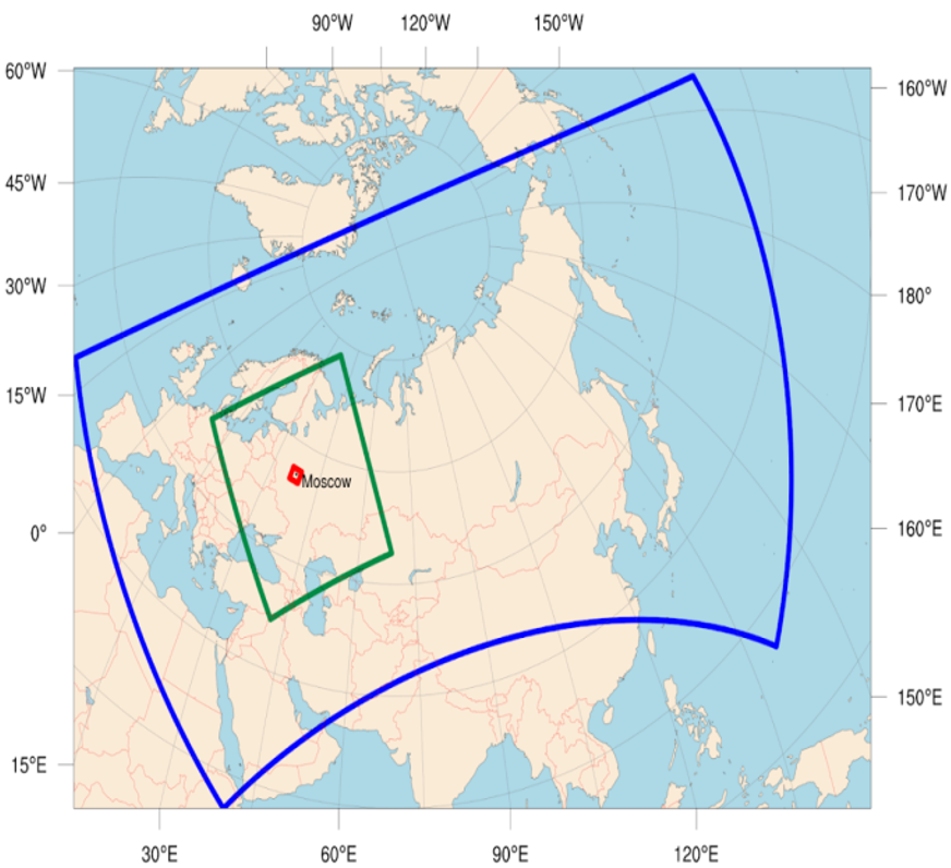
Fig.3. Hierarchy of COSMO-Ru computational domains: Blue contour - 6.6 km grid spacing, green contour - 2.2 km, red - 1 km.
Rapid update cycle with nudging assimilation of radar precipitation data is implemented for the nested domain with 2.2 km grid spacing.
7. Further information
Operational contact points: Gdaliy Rivin email: This email address is being protected from spambots. You need JavaScript enabled to view it., Inna Rozinkina email This email address is being protected from spambots. You need JavaScript enabled to view it.
URL for products charts: https://meteoinfo.ru/en/cosmo-ru6-maps, https://u2019.meteoinfo.ru/services/krasnoyarsk/workspace_1.php?type=map
URL for system documentation: description of technology and testing results: https://method.meteorf.ru/publ/sb/sb49/02.pdf (in Russian)
Links to the documentation of the latest version 6.0 of the COSMO model, containing a description of all its blocks (dynamic, physical and data assimilation) are available at https://www.cosmo-model.org/content/model/cosmo/default.htm.


